
Smarter Routes
Revolutionize Your Route Management
Plan Smarter, Execute Efficiently, Cover Everything
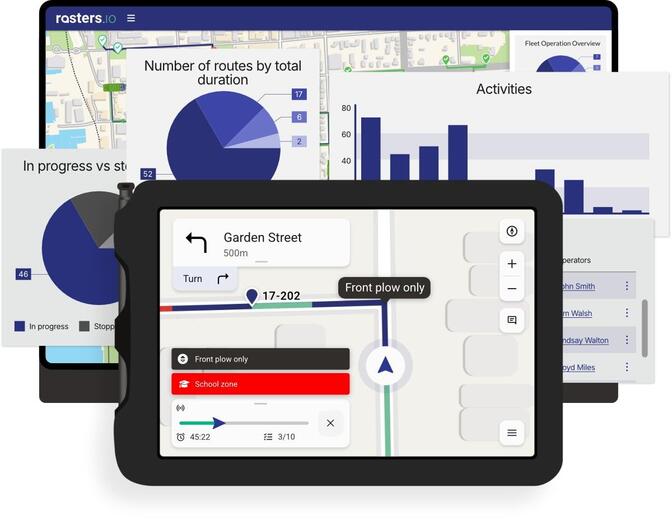
The platform facilitates the straightforward creation, editing, and management of turn-by-turn routes through its intuitive Draw Mode and comprehensive Vehicle History features. Specifically tailored for public works applications, it encompasses a variety of infrastructures such as sidewalks, parks, and cycle path routes. Additionally, the system supports specialized maneuvers pertinent to public works, including multiple lane passes and U‑turns. Users can also generate detailed route instructions, which can be effectively displayed to operators, enhancing operational efficiency and clarity in route navigation. Users can also generate detailed route instructions, which can be effectively displayed to operators, enhancing operational efficiency and clarity in route navigation.
What Makes Rasters.io Unique?
There's a big difference between public works routes and those used by commercial route management software. Public works routes are designed to follow predetermined routes, require domain-specific actions, and maximize coverage while minimizing costs for government agencies or organizations providing services to the public. On the other hand, commercial route management software is often tailored to the specific needs of businesses and focuses on factors like delivery times and profit margins. While both types of routes aim to streamline operations, they serve different purposes and require distinct approaches to planning and execution.
Public Works Routes

The route is more important than the destination
Not limited to the road network (you can go off-road)
Most likely planned in advance
Same route done multiple times
Some rules don’t apply
- Cleaning cycling paths with heavy machinery
- Waste collection behind a building
Commercial Routes
Route based on distance, time or fuel consumption
The destination is the objective, not the route
Follows every rule and regulation
Most routes are executed only once
Waypoints-based
Replace those outdated paper maps
Commercial fleet management software programs are great; however, they fail to satisfy the unique specifications of public works. This is the reason why numerous cities continue to employ paper maps to communicate their routes to their operators and subcontractors. With the help of Rasters.io, cities may quickly incorporate mapping technology into their current processes, increasing operational accuracy and efficiency. These are some use scenarios that our clients have come across.
01
Waste Management
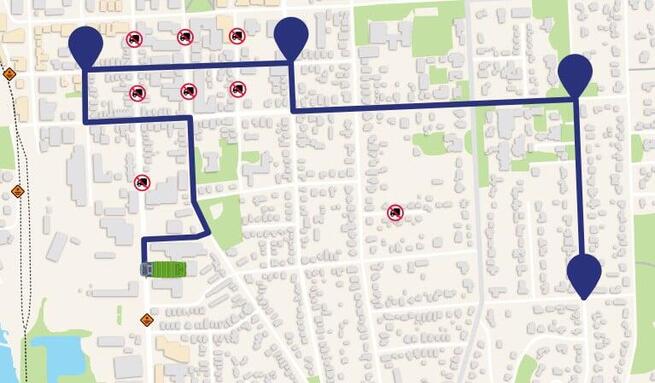
Off-route instructions must be taken into account when implementing waste management routes. A route may involve retrieving garbage containers from the rear of a building. The operator may be required to indicate the absence of a bin, the presence of obstacles in the path, or the placement of bins that are too far from the curb. The operator should also be aware of any potential safety hazards or obstructions that may impede the collection process.
02
Snow removal
Obstacles such as guiderails and raised manholes must be considered when designing snow removal routes. The operator must be aware of the spreader rate, the location to begin administering the abrasives, and the time to stop. There is also an environmental imperative to consider in relation to abrasives. Certain jurisdictions may place limits on the amount of resources that cities may use annually. We also provide add-ins to manage access and invoicing for northern clients who manage snow dumps.
03
Street sweeping
Street cleansing may be a daily occurrence in certain cities or a start-of-season activity. Off-road instructions for parking lots, sidewalks, or bike paths must be incorporated into those itineraries. The operator may be required to report a halted vehicle that is impeding their route. In order to accomplish the necessary level of service, they may require multiple passes on the same street.
04
Paths & Sidewalks
Walking paths, bike paths, and sidewalks are noteworthy examples. For example, sidewalks are offset and run along a street, rather than being an element of the street. You wouldn't want for the vehicle's history to be displayed on the road. The cleaning route for a sidewalk along a one-way street may be in the opposite direction. The maintenance and cleaning of a bike path typically necessitate the use of motorized equipment, such as a pickup truck, which is typically prohibited from operating on those paths.
05
Pothole repairs
Certain jurisdictions require cities to patrol their streets, identify potholes and other types of damage, and promptly remedy the damage in accordance with the level of service associated with each street, road, boulevard, or highway. A specialized module is accessible to cities that are required to submit reports that demonstrate their compliance with the mandated schedule for patrolling and repairing damage. Operators on other assignments or residents may also report potholes.
06
Parks management
The administration of parks necessitates the integration of task-based routes and off-road capabilities. An operator may be assigned the responsibility of overseeing the safety of numerous playgrounds, each of which has its own unique requirements, maintenance schedule, and conformity requirements.
See what our customers are saying!
A partner in your journey
Integration tailored to your need
Since its inception, NSim Technologies has worked hand-in-hand with cities to develop tools best suited for their needs. They also provided training and ongoing support to ensure successful implementation.

Purpose-build connector
Our investment in telemetry is in safe hands. Rasters.io already supports a vast array of telemetry devices. It can even work in tandem with other platforms. You can look at the GeoTab integration to see what's possible.
First class customer support
Our support team is consistently recognized as one of the most responsive and helpful in our industry, frequently resolving issues within minutes of their reporting. Our team genuinely goes above and beyond to guarantee that our customers are content.
Weatherproof your data
We will take every precaution to prevent data loss during severe weather, utilizing the store and forward workflow whenever feasible, as we understand the significance data loss can have on our customers' operations.
